Cruising Georgian Bay: A Guide for Great Lakes Boaters
Georgian Bay is the eastern arm of Lake Huron, separated from the main lake by the Bruce Peninsula and Manitoulin Island. It holds roughly 7,000 square kilometres of water, thousands of islands, and some of the most rewarding cruising on the Great Lakes. It is also one of the more demanding. The bay has its own weather, its own hazards, and its own rhythm, and boaters who treat it like an oversized lake get surprised in ways they do not enjoy. This guide covers the basics of what to expect if you are planning to cruise Georgian Bay for the first time or sharpening your plans for a return trip.
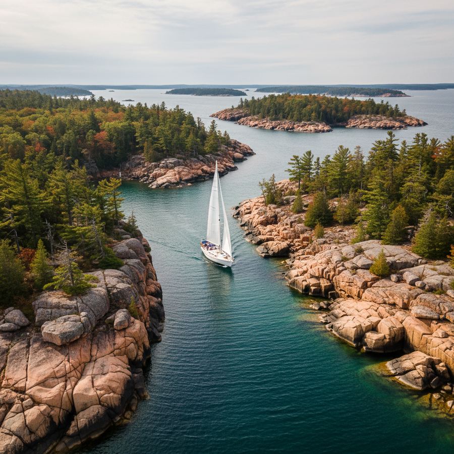
The 30,000 Islands
The eastern shore of Georgian Bay is lined with an archipelago that stretches roughly from Severn Sound north to Parry Sound and beyond. These are the 30,000 Islands, and they are the reason most cruisers come to the bay. The islands range from bare rock shoals barely above the waterline to forested granite humps with protected coves on the lee side. The inner channels, closer to the mainland, are relatively sheltered and well-marked. The outer islands are more exposed, less charted, and far more beautiful.
Navigation through the 30,000 Islands requires attention. The Canadian Hydrographic Service charts are essential, and a GPS chartplotter is not optional. Even with electronics, you need to watch for unmarked rocks, submerged shoals, and shifting sandbars near river mouths. The standard advice is to travel during daylight, keep your speed down in unfamiliar channels, and post a bow watch when threading tight passages. Most experienced Georgian Bay cruisers will tell you the same thing: slow down and look.
Anchorages
Georgian Bay has hundreds of anchorages, from wide-open roadsteads to tiny coves that hold one or two boats. The best anchorages are in the lee of the larger islands, where granite walls block the swell and the bottom is clean sand or rock with good holding. Many of the popular spots are well-documented in cruising guides and on community forums, but the real pleasure of the bay is finding your own unnamed cove and having it to yourself for the night.
A few things to watch for. Depths can change quickly near island shores. Wind direction matters more than wind speed when choosing an anchorage, because fetch builds fast in the open sections of the bay. And bugs can be fierce in June and early July, especially in sheltered spots near the mainland. If you are anchoring close to marshy shore, bring repellent and screens.
Weather Patterns
Georgian Bay generates its own weather systems, and conditions can change faster than you expect. The bay is large enough that fetch builds quickly in the open water, and the islands create their own wind patterns as air funnels through the channels. A forecast for "light southwest 10 to 15" can mean something very different in an open stretch of the bay than it does in a sheltered passage behind the islands.
Thunderstorms are the primary weather hazard in summer. They build fast, hit hard, and pass through in 30 to 60 minutes. When you see a dark line on the western horizon, you have less time than you think. Get your sails down, secure loose gear, and find shelter if you can. Lightning on the bay is common and genuinely dangerous.
Fog is less frequent than on the ocean but does occur, particularly in spring and early summer when the water is still cold. If fog rolls in, slow down and use your radar and horn. The islands do not move, but you might not see them until they are uncomfortably close.
Navigation Challenges
Beyond the shoals and rocks, Georgian Bay presents a few navigational challenges worth noting. The small craft route, marked by buoys and maintained by the Canadian Coast Guard, runs through the inner channels of the 30,000 Islands and is the safest corridor for most cruisers. It connects the major harbour towns and passes through some scenic stretches, though it avoids the most dramatic outer-island landscapes.
If you leave the marked route, you are largely on your own. Charts help, but they cannot show every rock. The standard cruising guides for the bay are worth buying and reading before you go. Local knowledge matters here more than in most cruising areas. If you can talk to someone who knows a particular stretch of coast, do it.
Cell service is patchy to nonexistent in the outer islands. VHF radio is your primary communication tool, and you should be monitoring Channel 16. The Coast Guard operates weather stations around the bay, and their broadcasts are the most reliable forecast source once you are away from the mainland.
Best Season
The cruising season on Georgian Bay runs roughly from late June through mid-September. July and August are the warmest months, with water temperatures that reach the low 20s Celsius in sheltered bays. June can be cold and buggy, but the bay is quieter and the anchorages are empty. September brings cooler nights, fewer boats, and spectacular colour in the shoreline forests. Most charter operations run from late June through early September.
Shoulder-season cruising is possible for experienced boaters, but the weather is less predictable, many harbour services are closed, and the water is cold enough that a fall overboard becomes a serious emergency.
Ports of Call
The bay has a string of harbour towns that serve as provisioning stops, weather harbours, and destinations in their own right. Penetanguishene and Midland anchor the southern end. Parry Sound is the main hub in the 30,000 Islands. Killarney, at the mouth of the North Channel, is a popular waypoint for boats heading west. Owen Sound and Tobermory sit on the western shore, at the base and tip of the Bruce Peninsula respectively.
Each of these towns has a marina, fuel, and basic provisioning. The larger ones have restaurants, groceries, and marine services. Smaller stops like Pointe au Baril and Britt have more limited facilities but make up for it with character and scenery. Plan your route with an eye on fuel range and provisioning needs, especially if you are heading into the outer islands where there is nothing but rock and water for days at a time.
What Makes It Worth the Effort
Georgian Bay is not the easiest cruising ground on the Great Lakes. It demands attention, preparation, and respect for conditions that can turn from pleasant to serious in less than an hour. But the payoff is a landscape unlike anything else in freshwater. Pink granite islands, deep green water, sunsets that light up the whole western sky, and the quiet of an anchorage where the only sound is the wind in the pines. For boaters who are willing to do the homework and stay sharp on the water, there is nothing quite like it. A good place to start planning is our weekend boating routes overview.